

By Arnav Kala
The hydraulic engineering of the Indus Valley Civilization (c. 2600–1900 BCE) reveals profound sophistication and environmental adaptability. From the arid island of Dholavira and the coastal plains of Lothal to the flood-prone Mohenjo‑Daro, Harappan engineers devised tailored systems for water harvesting, trade facilitation, urban sanitation, and flood resilience across varied landscapes. A systematic comparison of their approaches offers insight into the civilisation’s engineering methodology, civic planning, and the role of water in sustaining its urban centers. These hydraulic systems were not only practical necessities but also reflected a mature civic consciousness and a deep understanding of environmental challenges. Their
complexity and scale show a well-organized social structure capable of mobilising labor and resources across generations. Thus, analysing these three sites offers a compelling window into the technological ingenuity and societal advancements of the Harappans.
Dholavira: Reservoir Networks and Water Conservation in the Desert
Situated on the Khadirbet island in the arid Rann of Kutch, Dholavira faced an unforgiving environment characterised by low rainfall, saline groundwater, and limited surface water. Despite these challenges, Harappan engineers transformed the landscape into a sustainable urban center through one of the most advanced water management systems of the ancient world. At the heart of Dholavira’s hydraulic infrastructure were at least sixteen large stone-lined reservoirs, some excavated into the bedrock, others constructed using finely dressed sandstone. These reservoirs were located strategically around the citadel and middle town, aligning with the city’s natural topography to facilitate gravity-based water flow. The reservoirs varied in size and function, with some designed for storage, others for sedimentation, and a few for ceremonial or communal use.
Archaeological surveys, including ground-penetrating radar, have revealed an intricate network of bunds, check-dams, and inlet channels that collected monsoon runoff from the surrounding catchment. Seasonal streams like the Mansar and Manhar were dammed and diverted into stepped channels that fed the reservoirs, with silt traps placed along the way to prevent sediment accumulation. In some areas, engineers employed multi-tiered cascading systems that allowed water to be filtered and distributed in stages, maximising efficiency and purity. The urban design incorporated stepwells with access staircases, bathing platforms, and troughs, ensuring that both elite and common residents had access to clean water for drinking,
bathing, and ritual purposes.
Notably, one stepwell discovered in 1998 measures approximately 263 feet in length and 39 feet in width—larger than any other contemporary structure of its kind. The presence of troughs and feeder channels indicates a conscious effort to integrate hydraulic infrastructure with residential and civic architecture. Tanks and reservoirs near the citadel were likely used not only for water supply but also as a display of administrative control and ritual authority. The high degree of planning, labor investment, and architectural precision required for this system reflects a sophisticated understanding of hydrology, geology, and urban logistics. Dholavira’s water management strategy thus stands as a testament to Harappan ingenuity in confronting environmental adversity with technological innovation.
Lothal: Harbor Engineering Coupled with Urban Sanitation
Lothal, located near the Gulf of Khambhat in Gujarat, represents a different hydraulic paradigm, one rooted in maritime trade and urban hygiene. As a coastal settlement, Lothal was uniquely positioned to serve as a hub for the exchange of goods such as semi-precious stones, shell artifacts, and metalwork. The centerpiece of Lothal’s hydraulic infrastructure was its trapezoidal dockyard, measuring approximately 212 meters in length and 35 meters in width. This structure is considered one of the earliest known examples of tidal dock engineering. It was constructed using kiln-fired bricks and coated with a thick layer of mud plaster to ensure water resistance. The dockyard was connected to an ancient river, now dried, which once allowed ships to enter and unload cargo.
The design of the dockyard incorporated sluice gates and inlet channels that regulated water flow and prevented silt accumulation. Recent geological studies and sediment analysis have confirmed the presence of marine microfossils and gypsum crystals, validating the dock’s tidal function. While some scholars have proposed alternative theories suggesting it may have been a water reservoir, the balance of archaeological and geological evidence supports its role in maritime activities. The engineers of Lothal carefully oriented the dock to align with prevailing currents, thereby minimising silt deposition and maintaining navigability. Moreover, a spillway at one end of the structure served to drain excess water during high tides or storms,
showcasing advanced hydrodynamic knowledge.
Beyond the dockyard, Lothal featured an elaborate system of urban sanitation. The settlement included several brick-lined wells, public and private bathing platforms, and a complex grid of covered drains and soak pits. The drainage system was designed with corbelled roofs, inspection holes, and sedimentation chambers, allowing for regular cleaning and maintenance. These drains led either to cesspits or to external outflows near the dockyard, suggesting a dual-purpose use for waste management and tidal flushing. Residences were equipped with internal drains that connected to the main street sewers indicating a high level of domestic integration.
Lothal’s engineers also anticipated the problem of waterlogging and ensured that drainage channels were sloped appropriately to facilitate flow. The presence of raised plinths and flood protection bunds around residential blocks indicates awareness of seasonal flooding and storm surges. Unlike Dholavira, where water scarcity dictated infrastructure, Lothal’s system balanced the demands of commerce, sanitation, and flood control. The integration of harbor hydraulics with civic infrastructure marks Lothal as a versatile and forwardlooking urban center. Its engineers successfully blended trade facilitation with the imperatives of public health and environmental resilience, making it a unique example of multipurpose hydraulic
design in the ancient world.
Mohenjo-Daro: Wells, Baths, and Flood-Resilient Sanitation
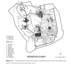
Mohenjo-Daro, located on the floodplain of the Indus River in present-day Sindh, Pakistan, was one of the largest and most developed cities of the Harappan civilization. The city’s proximity to the river posed significant challenges, including seasonal flooding, water contamination, and the need for large-scale urban sanitation. Harappan engineers addressed these issues through a highly organized and multi-layered hydraulic system that included over 700 brick-lined wells, public and private baths, street-side drains, and flood defense mechanisms. These features were not merely functional but also reflected a broader civic philosophy that emphasized hygiene, accessibility, and resilience.
The wells at Mohenjo-Daro were among the most striking features of the city. Constructed from standardised baked bricks, they were cylindrical in shape and sunk deep into the water table, ensuring a constant supply of fresh water. Most residential blocks had their own wells, suggesting that water access was decentralized and democratised. In addition to wells, houses often featured bathing rooms with sloped floors that drained into covered brick sewers, which in turn connected to larger drains running along the main streets. These sewers were covered with stone or brick slabs and equipped with manholes for inspection and cleaning. Such an arrangement points to an advanced understanding of urban hydraulics and maintenance logistics.
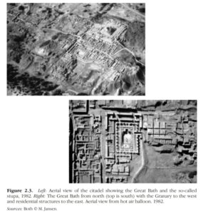
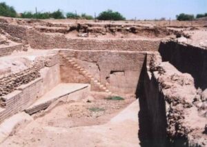
One of the most iconic structures in Mohenjo-Daro is the Great Bath, a watertight tank measuring 12 by 7 meters and about 2.4 meters deep. It was constructed using finely fitted bricks and a thick layer of natural bitumen for waterproofing. The bath had stairs on either end and was surrounded by a colonnaded verandah, suggesting it served not only hygienic but possibly ritualistic purposes. Water for the Great Bath was likely drawn from a nearby well and drained through a corbelled brick outlet into a large soak pit. The engineering precision required to build and maintain such a structure indicates a high level of technical expertise and organisational capacity.
Mohenjo-Daro also implemented flood mitigation strategies. Several areas of the city were built on raised platforms or mounds, possibly constructed from mud-brick rubble from earlier building phases. These platforms acted as levees, protecting critical structures from inundation. Archaeological layers suggest that rebuilding and elevation were ongoing processes, reflecting a long-term response to recurring floods. Additionally, the street grid was aligned with the topography to facilitate runoff, and some streets had open drains for stormwater management. The scale, redundancy, and integration of these hydraulic features show Mohenjo-Daro’s status as a model of ancient urban planning. It represents a peak in Harappan civil
engineering, where water management was not only essential for survival but also a defining element of civic identity.
Conclusion
The hydraulic systems of Dholavira, Lothal, and Mohenjo‑Daro collectively embody the adaptive ingenuity of Harappan engineering across ecosystems. Dholavira’s reservoirs harness water in a harsh desert, Lothal’s dockyard facilitates trade alongside sanitation, and Mohenjo‑Daro’s wells, baths, and drains manage water supply and floods in a dense urban core. Unified by gravity-fed design, sedimentmanagement strategies, and civic maintenance infrastructure, yet differentiated by material use and environmental response, these sites stand as enduring testaments to an ancient civilisation’s mastery over water. Their innovations not only sustained Harappan urbanism but also laid the groundwork for subsequent water-engineering traditions in South Asia. Through their unique but interconnected solutions, these cities reflect a civilisation well adapted to the challenges and opportunities presented by their environments.
References
1. P. K. Singh, Pankaj Dey & S. K. Jain et al., “Hydrology and water resources management in ancient India,” Hydrology and Earth System Sciences, 2020
2. Michael Jansen, “Mohenjo‑Daro, Indus Valley Civilization: Water Supply and Water Use in One of the Largest Bronze Age Cities,” ICOMOS Open Archive, 2011
3. M.A.Z. Mughal, “Mohenjo‑Daro’s Sewers,” in World History Encyclopedia, 2011
4. Ekta Gupta & V.N. Prabhakar, “Paleo‑environmental Evidence for Tidal Dockyard at Lothal,” Journal of Archaeological Science, 2022