
The science of cartography has often been overlooked and underappreciated. Before the advent of satellites and GPS, cartographers like Nain Singh Rawat ,physically traversed arduous terrains to draw landscapes on paper. In British India, cartography was essential not only for understanding the area administered by the British but also for discovering new trade routes and natural resources.
When the British started consolidating their hold over India, they became concerned with their ignorance of the lands beyond the northern mountain ranges. This concern was echoed by the survey officers of the Great Trigonometric Survey, an institution established in the late eighteenth century. The British had mapped their territory to Kashmir and Kumaon, but areas beyond were almost impenetrable due to harsh climates. Adding to this were the unsettled conditions in Chinese Turkmenistan, the secluded nature of Tibet, hostility from Indus Valley tribes towards European travellers, and the murder of German explorer Adolphe von Schlagintweit in 1857. Major Kenneth Mason noted, “Our Transfrontier maps were almost blank.” Against this backdrop, Captain T.G. Montgomerie, a surveyor and cartographer with the Great Trigonometric Survey, advocated for the inclusion of Indians in surveying these terrains. They came to be known as ‘pundits’, after the eponym Pundit Nain Singh Rawat.

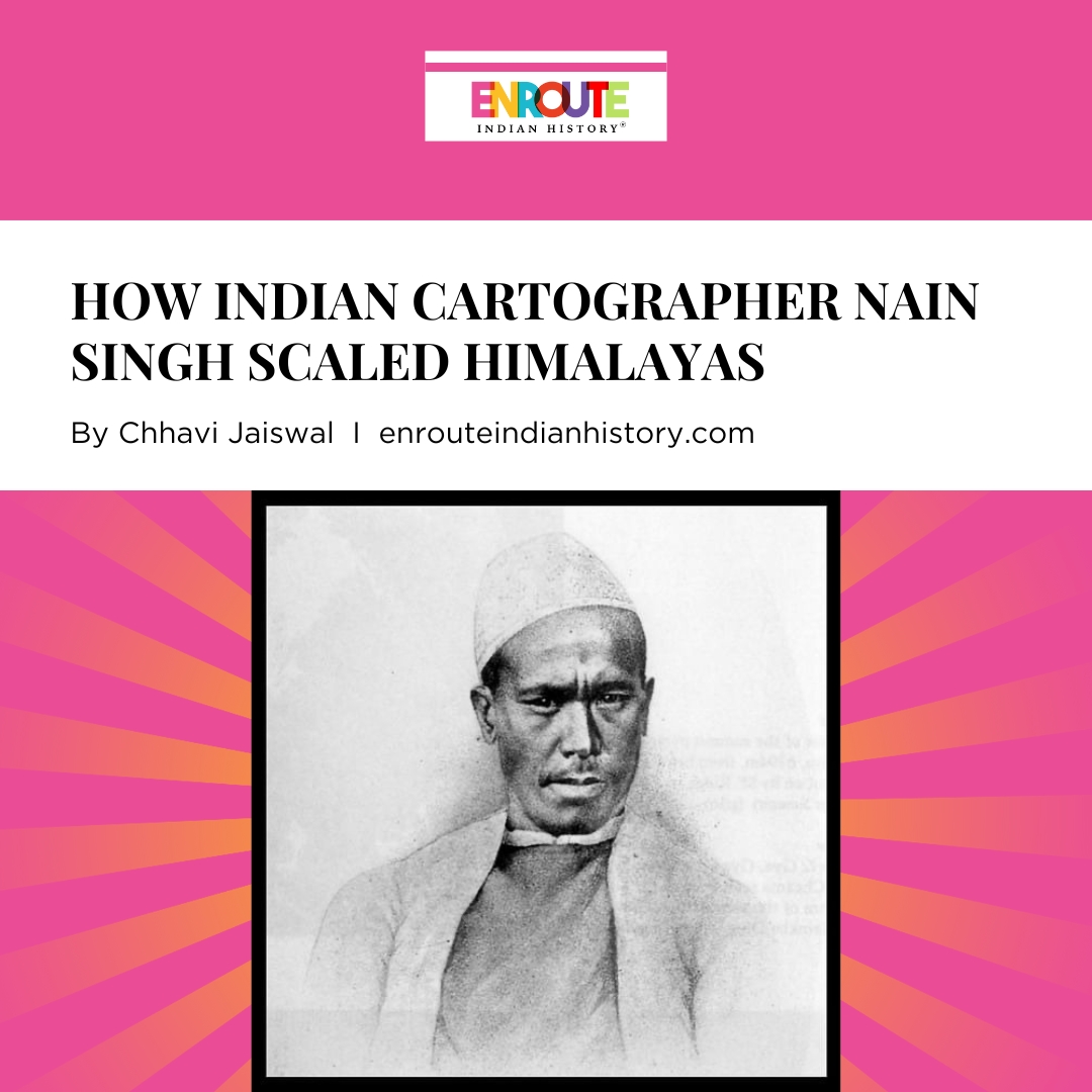
(Pundit Nain Singh Rawat; Source: PBS)
In 1862, this plan was officially sanctioned, requiring the selection of qualified men. Montgomerie approached Major Edmund Smyth, a superintendent of the education department for recruits, who then recommended the Bhotia cousins, Pundit Nain Singh Rawat and Mani Singh, from Milam. The Bhotias, of Tibetan origin from Kumaon, were skilled in high-altitude travel, spoke Tibetan, and traded with Tibetans. Nain Singh and Mani Singh had previously accompanied the Schlagintweit brothers on an expedition to Turkmenistan and Ladakh, and during their exchange, Nain Singh learned cartography and instrument use and taught them the Tibetan language. Impressed by him, the brothers offered him to accompany them to England but Nain Singh had to decline due to social stigma and his cousin’s disapproval.
Nain Singh, initially a teacher (hence the codename “pundit”), became involved with the government as a spy. In 1858, Colonel Henry Strachey, aware of Nain Singh’s previous expedition experience, employed him as a servant, leading to his introduction to Edmund Smyth. Smyth played a key role in Nain Singh’s becoming a school teacher. In 1862, the latter was tasked with opening a new school in Dharma Patti. Even though it was a respectable job, it became difficult for Rawat to manage his finances. Eventually, he disclosed his financial struggles to Smyth. This led the latter to recommend Nain and Mani Singh to the Survey of India.
Nain Singh and Mani Singh began their Great Trigonometric Survey training in Dehradun in February 1863. Major (later General) Walker and Montgomerie devised rigorous training, teaching them the use of survey instruments like perambulators and cyclometers and how to walk at a consistent pace for mapping. After a year of training, they were ready for fieldwork as professional surveyors and cartographers.
In March 1864, Nain Singh and Mani Singh began their exploration for the Great Trigonometric Survey, mapping British India and the trans-Himalayan region. They started their route survey from Bareilly. Returning to Milam, they attempted to cross into Gartok but found the route impractical. Directed by Montgomerie, they travelled via Kathmandu and intersected the road between Lhasa and Ghartok. They surveyed the Tsangpo River and accurately located Lhasa on the map, an accomplishment previous cartographers had failed to achieve.
In 1865, after a 450-mile journey in two months, they reached Kathmandu. Using rosary beads to silently count paces and hiding their instruments in a prayer wheel, they evaded customs inspections. Blocked by snow, they had to detour through Kirong disguised as Bashahri traders (who regularly traded with the Tibetans) but were denied entry by customs officials. Mani Singh attempted another route but turned back due to health issues. Nain Singh, disguised as a Ladakhi, joined a merchant caravan to Lhasa. After crossing the No La pass, he finally confirmed that the Tsangpo River flowed into India as the Brahmaputra. Following this, he joined a caravan from Kashmir and arrived in Lhasa on January 10, 1866. He stayed for three months, surveying the Potala Palace and making astronomical observations. His report provided valuable cultural insights. Recognized by two Muslim traders, he immediately left the city.
Nain Singh Rawat
Nain Singh journeyed west along the Tsangpo River, crossed Mahem La, and reached the Kailash Mansarovar region. He arrived in Milam on June 29, 1866, and returned to Dehradun with Mani in July. Over 18 months, he had travelled over 2400 km, meticulously surveying his entire route. For his efforts, he was awarded a gold chronometer by the Royal Geographical Society.

(The Gold Chronometer awarded by the Royal Geographical Society; Source: The Himalayan Club)
After a few months of rest and working as a trainer for the Great Trigonometric Survey, Nain Singh embarked on a second expedition with cousins Mani and Kalyan Singh and a team of 11. Disguised as Bashahri traders, they entered western Tibet aiming for the Thokjalung goldfields which were famed since antiquity. But their cover was compromised in Giachuraf, leaving Mani as a hostage while Nain Singh continued. After reaching his destination, he verified the existence of goldmines, a subject that had been of longstanding interest to the British, and completed the six-month mission that surveyed 850 miles and 1800 square miles, recording 190 latitudes and altitudes and identifying various peaks. This was another significant journey in this great cartographer’s career as a Pundit.
From 1867 to 1873, Nain Singh worked as a teacher-trainer for the Survey of India and rewrote his travel diaries. In February 1873, Colonel Montgomerie sent him on an expedition to Lhasa with T. Douglas Forsyth. Nain Singh stayed in Yarkand for five months and documented the region while the team carried on. The group discovered a direct route to Turkistan from India, and each member contributed to a book that was published on this expedition.
After the Forsyth Mission, Nain Singh embarked on his fourth and final expedition, travelling from Leh to Lhasa via a northern route, returning through Samye, Tawang, and Calcutta to Dehradun. With Captain Henry Trotter and Governor William Johnson ensuring his safe passage, Singh disguised as a trader with twenty-six sheep and traversed the remote Chang Tang plateau, surveying unknown lakes and encountering nomadic Changpa. He visited the Thok Daurakpa goldmine, Dangra Yum Lake, and Tengri Nor, a lake uncharted by Europeans.
Upon reaching Lhasa, rumours of Chinese authorities searching for a British agent forced him to cut his stay to two days. To avoid exposure, Singh sent his survey notes to Trotter and pretended to head on a pilgrimage. He crossed the Tsangpo River, surveyed its lower course, and traversed the Himalayas via the Karkang Pass. Detained in Tawang for six weeks due to local trade monopolies, he finally crossed into British India in March 1875. His journey covered nearly 2800 miles, 2400 of which were unexplored, contributing significantly to geographical understanding. During this expedition, he further explored the mountain Nanglong Kangri which was later renamed to Nain Singh range until 1961 when geographers decided that natural features should not be named after individuals.

(Source: PBS)
Nain Singh never undertook an expedition again after this due to his deteriorating health and spent the rest of his career training recruits. He was honoured with the Patron’s Medal in 1877 for his extensive journeys and surveys contributing significantly to the mapping of Asia. He was further presented with a gold medal by Lord Lytton in 1878 and appointed a Companion of the Indian Empire. He authored three diaries and a book, together called “Akshans Darpan”. These have emerged as an important source in the history of surveying and travel writing.

(A page from Nain Singh’s diary; Source: The Himalayan Club)
Rawat’s invaluable contributions to cartography and the mapping of Asia facilitated the opening of new trade routes and the discovery of numerous lakes and mountain ranges. Henry Yule fittingly described him as the “pundit of pundits.” Through his unparalleled skill and unwavering perseverance, this exceptional explorer, surveyor and cartographer navigated the harshest terrains, significantly contributed towards the knowledge of the Himalayas, and determined, with accuracy, the location of many regions that led to the perfecting and filling of longstanding gaps in the maps of the Indian subcontinent that had persisted for centuries.

(A postal stamp was issued by the Government of India in his honour on 27 June 2004; Source: Wikimedia Commons)
References:
Dean, Riaz. Mapping the Great Game. Explorers, Spies and Maps in 19th-Century Asia. Casemate Publishers, 2020.
Waller, Derek. The Pundits: British Exploration of Tibet and Central Asia. The University Press of Kentucky, 1990.
Pathak, Shekhar. Pundit Nain Singh Rawat: Explorer Extraordinaire. The Himalayan Journal. Vol. 72. no. 2, 2017 https://www.himalayanclub.org/hj/72/2/pundit-nain-singh-rawat-explorer-extraordinaire
Mason, Kenneth. “Kishen Singh and the Indian Explorers.” The Geographical Journal, vol. 62, no. 6, 1923, pp. 429–40. JSTOR, https://doi.org/10.2307/1781169.