Article Written By EIH Researcher And Writer
Barnak Das
Compared to Europe or the Arabic world, the science of cartography often appears non-existent in South Asia in the eyes of a general viewer. Much of this has to do with associating cartography or map-making exclusively with the European tradition which arrived in the Indian subcontinent with the Portuguese, English and French. Undoubtedly, the methods like surveys and use of modern tools rendered excellent precision in the European maps, but that does not mean that an indigenous tradition of map-making in the subcontinent never existed or that it was somehow insignificant. As stated by scholars like Gole and Schwartzberg, most indigenous maps did not survive till they were given a chance to get studied; this has led to the idea that there never existed a tradition of cartography in India. The view is not true because there has been a rich history of geographical knowledge even before the introduction of the modern practice of cartography during the colonial period.
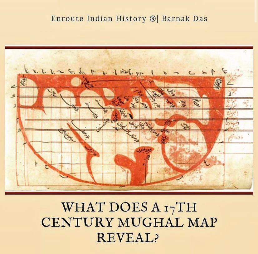
One of the most notable indigenous maps from India, a world map, gives us a chance to study the knowledge of cartography preceding the onset of European colonization. The map in question is the “Map of the Inhabited Quarter,” which is part of a comprehensive thirty-three-page atlas in Persian called the Shahid-i-Sadiq. The author, Muhammad Sadiq ibn Muhammad Salih Isfahani was an Indian Muslim of Jaunpur who lived during the reign of Shah Jahan. Not much else is known about the author other than the fact that he authored the map in 1647, the same year the Mughal emperor retrieved his armies back from the infamous Balkh campaign. The map is unique in the sense that a modern viewer will find it strange to notice it oriented in the opposite cardinal directions, i.e., the south on the top and the north on the bottom. It is painted with ink and watercolor on paper. To the topmost right corner of the map are the Insulae Fortunatae or Canary Islands. On the left is the western part of Africa, below it is Andalusia (Spain) and Frankia (France). The equator runs through the continent of Africa, named the ‘land of the elephants.’ Other countries like Morocco, Egypt, Syria, most of the Dar-al-Islam appear in the map, though sometimes incorrect of their geographic position. In the center of the map is the triangular shaped Caspian Sea, Iran on the right of it and below it Russia and Turkestan. On the left appears a peninsula with the names India and Sind. Going further in the direction is the two cusped peninsula of Chin and Mahachin (China). Beyond this, appear the mysterious Katha and the wall of the Gog and Magog. Next to it is the Waqwaq islands.
On close analysis of the map we will find that it divides the earth into seven climes or climates, it is oriented with the south on top and degrees of longitude run alongside the equator and the latitudes run along the rim of the half disk. The meridians do not meet at the pole or converge, but run as straight lines which meet the rim at various points. This results in the formation of a square grid pattern inside the map, equal in area. Many of the chief towns are placed inside such squares with their coordinates alongside the text. Isfahani also defines legends and use of colors in the map. He mentions that the cuts in vermillion represent the rivers and spaces filled in vermillion represent the oceans. Apart from the geographic details, the map by Isfahani also has some mythical elements. The author is not free from the belief that monstrous races exist in Central Asia, near the hook shape, which experts believe is the lake Baikal in Siberia, on the lower left side of the map. He mentions a mythical wall exists near the waterbody.
The work of Isfahani and the map of the Inhabited Quarter was a major development in the history Indo-Islamic cartography. It is one of the few extant maps from pre-colonial India, a valuable document which proves that cartographic knowledge of South Asians existed even before the arrival of the Europeans. Today the copy of the map can be found well preserved in the British Library of London.

Bibliography
#204 map of the “inhabited quarter” | cartographic images. (n.d.). Retrieved September 3, 2022, from http://www.myoldmaps.com/early-medieval-monographs/204-map-of-the-inhabited/
Habib, I. (1974). CARTOGRAPHY IN MUGHAL INDIA. Proceedings of the Indian History Congress, 35, 150–162. http://www.jstor.org/stable/44138777
Map of the “inhabited quarter”, from the shahid-i sadiq by sadiq isfahani(Oriented with south at the top). (n.d.). MUGHAL LIBRARY. Retrieved September 3, 2022, from https://www.mughallibrary.com/maps-1/map-of-the-%22inhabited-quarter%22%2C-from-the-shahid-i-sadiq-by-sadiq-isfahani-%28oriented-with-south-at-the-top%29


