

By Tehreem Asad
The Harappan Civilisation, or the Indus Valley Civilisation, was a significant Bronze Age civilisation in South Asia. It flourished during the period of c.2600 BCE to 1900 BCE. It was during the time of the Harappan Civilisation that the very first cities came up in the Indian subcontinent. One way to look at urbanism is to understand the organisation of people and institutions within the city, in other words, urban planning. Cities of the Harappan civilisation are known for their meticulous and well-organised town planning, which was fairly sophisticated for Bronze Age settlements. One such site is Dholavira, located in the Great Rann of Kutch in Gujarat, on an arid island called Khadir Bet.
The city of Dholavira is one of the two largest known Indus settlements in India and one of the five largest in the subcontinent. The site was first officially discovered by Jagat Pati Joshi of the Archaeological Survey of India in 1967-68. It was excavated for 13 field seasons between 1989 and 2005 under R.S. Bisht. It is one of South Asia’s best-preserved urban sites that was established between the period of the 3rd to the mid-2nd millennium BCE. The well-thought-out and developed town-planning of Dholavira and its water management system make it a site of great importance.
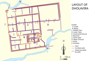
Layout of Dholavira
(Courtesy: https://en.wikipedia.org/wiki/Dholavira#/media/File:Dholavira-layout-en.svg)
City and Urban Planning
Central to the discussion of the urban design of Dholavira are the concepts of ‘city’ and ‘urban planning’. It is difficult to give an absolute definition for the term ‘city’ because of the lack of a universally agreed-upon description. V. Gordon Childe made one of the first attempts to define a ‘city’ academically. According to Childe, the earliest cities were a result of the ‘urban revolution,’ and ten characteristic features of the first cities made them different from the villages of the time. The ten features are (1) larger population, (2) full-time specialists in non-agricultural activities, (3) handing over of agricultural surplus as tax, (4) presence of monumental buildings, (5) class stratification in society (6) existence of a system of writing, (7) development of useful sciences, (8) presence of sophisticated artistic styles, (9) significant amount of long-distance trade, and (10) residence-based state organisation. Later scholars, however, have disputed Childe’s theory on several grounds. Alternative theories have tried to condense the characteristic features of a city, focused more on specific features, or identified new defining features. It is also important to take into consideration the fact that many of these theories were constructed based on only the initial archaeological investigations conducted in premodern urban settlements. The recent scholarship on the concept of urbanism suggests that the notion of cities cannot be thought of as a heterogeneous phenomenon.
Circular houses of Dholavira
(Courtesy: https://en.wikipedia.org/wiki/Dholavira#/media/File:Cicular_houses_Dholavira.jpg)
In archaeological terms, a settlement can be classified as a city based on material evidence. For instance, the large size of a settlement indicates high population density. The presence of monumental architecture for public purposes and a systematic town planning suggests the use of labour that is involved in non-agricultural activities and, possibly, also the existence of a state. If a large amount of luxury goods is excavated in a site, it indicates the development of craft specialisation or the presence of long-distance trade. Additionally, hierarchical archaeological differences could make clear the distinction between the city and its hinterland. Although these criteria are not absolute or inflexible, they provide an idea about some features that can help identify urban settlements. These features can also be observed in the city of Dholavira.
The Urban Design of Dholavira
Dholavira is arranged roughly in the shape of a parallelogram with the longer side of the quadrilateral running from east to west. Like most of the major Indus urban settlements, Dholavira is surrounded by a mud-brick fortification on all four sides, which demarcates the city from its surrounding area. There are two major gateways located between the northern and southern walls. The settlement is divided into three principal segments, namely the Citadel, the Middle Town, and the Lower Town. These divisions are termed as such based on their relative location, planning, defences, and architecture, and together these structures are arranged in an ‘L’ shape. Apart from this, the site also includes many fortifications, two stadia, an annexe, and a series of water reservoirs. Sandstones and mud-bricks were primarily used for the construction of structures within the city. Broad roads were laid out on both sides of the city wall, which encircled the entire settlement.
View of the citadel
(Courtesy: whc.unesco.org/en/documents/181369)
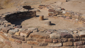
The citadel at Dholavira is situated in the southern part of the city. It is thought to be the original location of the first settlement. It had massive fortifications that reached up to 18 meters in height and were around 15 to 18 metres thick. A major bulk of the architectural elements of Dholavira have been found in the citadel. The citadel has two conjoined and fortified subdivisions called the ‘castle’, located on the east, and ‘bailey’, located towards the west. The castle, which is situated on the tallest mound in the city, has elaborate defensive structures and is equipped with gates, towers, and salients. Archaeologists have identified a bead workshop, water reservoirs, a stepwell, and residential structures in varying stages here. Bailey, on the other hand, is comparatively smaller in size and is surrounded by narrower walls. In the western part of the Bailey, there is a water reservoir that is supplied with water through a network of drains. It is believed that the buildings along the northern and southern flanks housed the residents of the citadel, probably the administrative officials and ministers.
The citadel has gateways in the centre of its four walls. Situated between the citadel and the middle town was a large, wide ground, called the stadium, which was probably meant for the purpose of community gatherings. There is another structure to the south of the castle along the city wall, labeled the annexe, which was likely meant as an accommodation for servants who attended the elite residents of the castle. In total, fourteen gates have been found in the complex, out of which some are elaborate and some are simple. They are present in various sections of the area. The castle has five gates, the bailey has two, the stadium has four, and one and two gates are present in the middle town and the annexe, respectively. No gates are present in the lower town.
To the north of the citadel was the enclosed middle town, to the east of which lay the lower town. The middle town is enclosed by a wall (measuring 360 × 250 m) with four gateways. This area developed naturally near the northern side of the citadel initially. Later, a planned effort was made to lay out the main streets further north and to relocate parts of the settlement in order to create a ceremonial ground. As a result of this, the outer limits of the middle town were fortified, and a system of check dams was constructed to capture water from the seasonal Mansar stream. Because the centre of the middle town lay on naturally elevated ground, the drains were built along the streets to channel surface runoff into nearby reservoirs. The middle town is organised on a grid-based street system that divides it into square units, within which houses and workshops are constructed. The streets are arranged according to their width, including arterial roads (4.2–5.8 m), sub-streets (3.2–3.5 m), lanes (1.2–1.7 m), and narrower by-lanes.

General view of Middle Town
(Courtesy:whc.unesco.org/en/documents/181364)
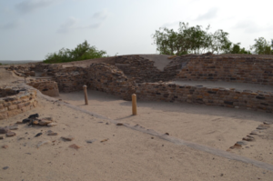
The lower town did not have any separate walls of its own, but it was situated within the general fortification of the city. It appears to have been established after a major earthquake. Excavations in this area indicate that the main street from the middle town did not continue in a straight line into this area, and shows a departure from the earlier planned layout. Archaeological evidence also shows that the earlier practice of coating buildings with layers of white and pink clay was discontinued suddenly after the disaster. Afterwards, buildings were left as exposed masonry or were finished only with mud plaster. Like most Harappan settlements, the lower town of Dholavira was primarily a residential area where evidence of houses and areas is found. It had good access to water sources located to the south as well as to the north. The streets of the lower town are organised in a fashion similar to the middle town. A variety of craft activities, such as bead making, shell working, and pottery making, were conducted in this area.
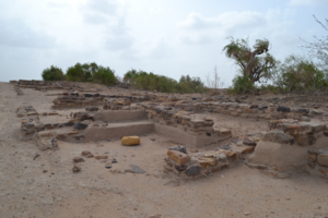
General view of residential block in the lower town
(Courtesy: whc.unesco.org/en/documents/181368)
An exceptional feature of the city design in Dholavira was the presence of an elaborate rain harvesting and management system. In fact, the city itself was situated in an area that would ensure a supply of water, since the ecological conditions of this area made it drought-prone and made agriculture difficult. There were small sandstone hills towards the north of the city, and during the rains, water flowed down from them through small streams. Dholavira was built between two such streams, Mansar in the north and Manhar in the south. Dams were built on these streams to maneuver them in a way that the water from them would drain into the city. Within the walled area, there were a series of water reservoirs, at least 16, that were constructed along all sides, except for a short stretch of just over 200 metres in the central eastern zone. Nearly 17 hectares of the total enclosed area were dedicated to water reservoirs. These reservoirs are considered to be one of the finest and best-preserved examples of architectural development within the Harappan civilisation discovered thus far.
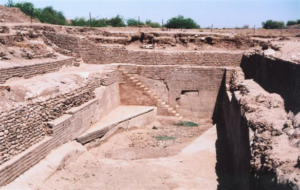
Water Reservoir, Dholavira
(Courtesy: https://en.wikipedia.org/wiki/Dholavira#/media/File:Dholavira1.JPG)
Several artefacts from all historical stages have been found in the site. This includes jewelry (of materials like gold, ivory, semiprecious stones, and terracotta), ceramics, processing tools, drills, seals, terracotta figurines, shell artifacts, stone bangles, etc. Bead processing workshops, along with plenty of beads, are also found. There is also a signboard found in the excavations of Dholavira, which contains 10 large gypsum signs. We also find evidence of long-distance trade with regions like Mesopotamia and the Oman peninsula.
There is substantial evidence for habitation even outside the fortified city. Also outside the city is a Cemetery which covers an area of more than 50 hectares. Save for a few exceptions, most burials in the cemetery are cenotaphs and memorials in nature. The burials found here can be classified into 6 types: rectangular memorials, cairns, composite graves, fractional burials, inhumation, and hemispherical monuments.
The occupation of Dholavira began in c. 3000 BCE. It spans around 1,500 years and is divided into 7 stages. Urbanisation began in Stage I and developed through Stages II, III, and IV. Stages I-III (3000-2500 BCE) are identified as the Dholavira culture. Stages IV and V (2500-2000 BCE) coincide with the Harappan culture, where in Stage V, urbanism began to decline. The site was abandoned temporarily between 2000 BCE and 1950 BCE. In Stage VI (1950-1800 BCE), which is marked as the late Harappan culture, the city shrank into a small town. The area was unoccupied once again for a period between 1800 BCE and 1500 BCE. Finally, in Stage VII (1500-1450 BCE), which corresponds to the post-Harappan culture, the site was completely deurbanised and was not occupied again.
REFERENCES:
1. Bisht, Ravindra Singh. Dholavira Excavations: 1990-1994.
2. Bisht, R. S. “Dholavira and Banawali: Two Different Paradigms of the Harappan Urbis Forma”. Puratattva: Bulletin of the Indian Archaeological Society, 29, 1999, 14–37.
3. Fernández-Götz, Manuel, and Michael E. Smith. “The Archaeology of Early Cities: ‘What Is the City but the People?’” Annual Review of Anthropology, vol. 53, no. 1, Oct. 2024, pp. 231–47. https://doi.org/10.1146/annurev-anthro-041222-094823.
4. Harish, Swastik. “Dholavira: Ancient Water Harnessing System.” Context – Built, Living and Natural, Dronah, 2009.
5. Fukao, Junichi. “Cities in India: an archaeological perspective.” Cities in South Asia, May 2015, pp. 33–42. https://doi.org/10.4324/9781315735825-10.
6. Singh, Upinder. “The Harappan Civilization, C. 2600–1900 BCE.” A History of Ancient and Early Medieval India: From the Stone Age to the 12th Century, Pearson, 2009, pp. 132–81.
7. International Council on Monuments and Sites (ICOMOS). Dholavira: A Harappan City (India). No. 1645. UNESCO, 2021.


