

By Aryan Singh
Monsoon in Delhi is always a welcome break — a sigh of relief from the scorching, sweat-soaked heat that the city endures every summer. But while the rains bring joy, they also carry chaos. Waterlogged roads, endless traffic jams, and swelling drains become a daily ordeal. Yet, one of the most dangerous consequences lurks quietly — the rising waters of the Yamuna.
For most of the year, the Yamuna flows gently, calm and unthreatening. But during the monsoon, as the entire North India is lashed by heavy rain, this seemingly peaceful river turns monstrous. It was during the monsoon of 1978 that the Yamuna truly unleashed its fury — a time still etched in the memories of Delhi residents. 47 years back, on a gloomy September morning in 1978, the bustling capital of India awoke to an unexpected nightmare. Streets were no longer roads—they were rivers. Homes, shops, schools, and temples stood knee-deep, and in some places, neck-deep in muddy water. Families scrambled to rescue what little they could—documents, clothes, food—while the mighty Yamuna River, swollen by days of relentless monsoon rain and massive water discharge from upstream barrages, surged through the city with unstoppable force.
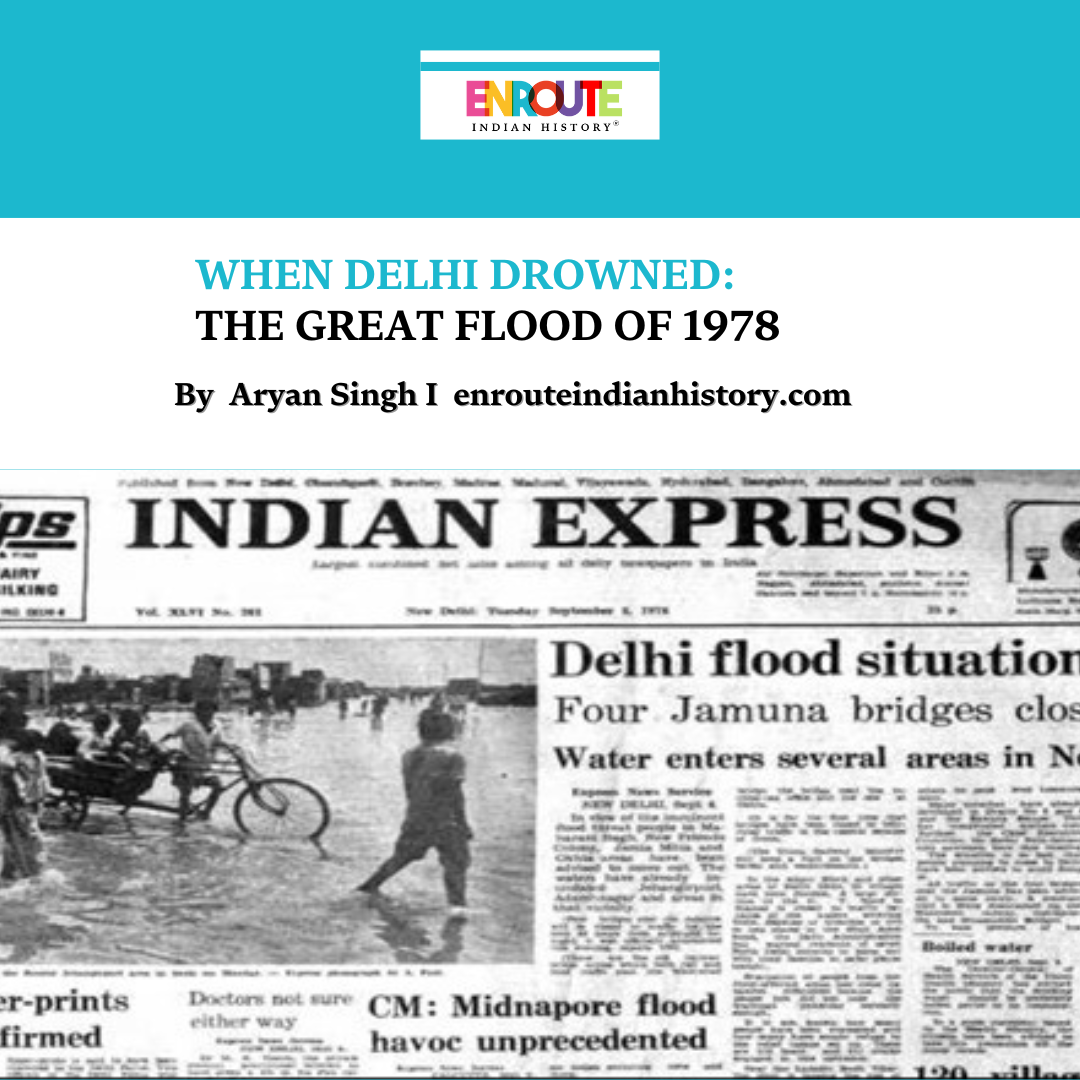
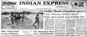
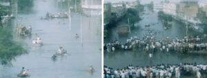
It was the first week of September 1978, and Delhi witnessed the fury of the Yamuna like never before. On the morning of September 6th, the river overflowed past its banks, reaching an alarming 204.49 meters at the old rail bridge or Lohe-ka-Pul (2.66m above danger level). The crisis worsened when the Tajewala barrage, now known as the Hathnikund barrage in Haryana, released a staggering 700,000 cusecs of water, pushing the Yamuna to an all-time high of 207.49 meters, well above the danger mark. This became the river’s highest recorded level since 1908, transforming the calm lifeline of the city into a raging, unstoppable force. The flood paralysed civic life, exposed the cracks in urban planning, and triggered one of the biggest relief operations in the city’s history.
Source: Hindu Archives

Source: India Today, 1978 photo of the Old Rail Bridge during the Flood
This article revisits those fateful days, explores what caused the catastrophe, and reflects on how a city of millions was brought to its knees by the fury of a river it once took for granted.
In the 1970s, Delhi was a growing capital with expanding neighbourhoods, a rising population, and fragile infrastructure. Monsoons were an annual challenge, but nothing had prepared the city for what was to come. That year, hefty rainfall across North India had already pushed rivers past their danger marks. The Yamuna, fed by rains in the hills and plains, started rising ominously. The Yamuna’s flow in Delhi mostly depends on the water released from the Hathnikund or Tajewala barrage, located about 240 km upstream. When there is heavy rainfall, extra water is released, and it takes around 48 hours for the river level to rise in Delhi.s
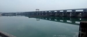
The Tajewala barrage, completed in 1873, was built to control the flow of the Yamuna River in Uttar Pradesh and Haryana through two main canals — the Western Yamuna Canal and the Eastern Yamuna Canal. In 1999, the Hathnikund barrage was completed to replace the aged Tajewala Barrage, which is now out of service. During periods of heavy rainfall, when the water flow at the barrage exceeds 16,500 cusecs, the excess water is released directly into the main river channel, leading to a rise in the water level.
Source: Wikipedia encyclopedia, View of Hathnikund Barrage
Source: Indian Express Archive
When the water level rose to 207.49 m — well above the danger mark — it pushed water back into the city’s drains, triggering chaos. Weak rural embankments couldn’t hold the pressure, leading to widespread breaches that flooded 43 sq km of farmland under two metres of water and ruined the kharif crops. Back then, the embankments weren’t as strong as today’s; authorities tried to slow the water with sandbags, but it barely helped.
The river swept across Delhi, flooding areas like Jahangir Puri, Model Town, Mukherjee Nagar, Nirankari Colony, Delhi University, Okhla, Civil Lines, New Friends Colony, Maharani Bagh, etc, virtually sweeping large parts of Delhi. In North Delhi, 30 Villages were flooded. A large section of GT Karnal Road was closed when water entered there. The four bridges over the Yamuna – Old railway, Wazirabad, Okhla, and one near the income tax office were closed due to safety measures that were taken.
The rise in the Yamuna’s water level doesn’t just flood its banks — it also causes water to flow backward into the Najafgarh drain, which is Delhi’s largest drain. This backflow, combined with heavy rainfall, leads to severe flooding in the Sahibi Nadi. Originating near Jaipur in Rajasthan, the Sahibi River travels through Alwar and Gurgaon before entering Delhi near Dhansa village. During the flood, the Dhansa bund was breached, and an enormous peak discharge of about 33,000 cusecs poured into Delhi, far exceeding the Najafgarh drain’s designed capacity of just 3,000 cusecs.
Source: India Today

Source: India Today
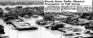
A powerful backflow from the Najafgarh drain turned large parts of West Delhi — like Janakpuri, Hastsal, Uttam Nagar, Pankha Road, and Vishnu Garden — into flooded islands. Over 2.5 lakh people had to abandon their homes, and sadly, 20 lives were lost. The army rushed in to save people stranded by the rising waters, bringing food and water to those in need. The government quickly set up relief camps to shelter families until the floodwaters went down. The destruction was huge, with damage to crops, houses, and public services adding up to around ₹176.1 crores. In total 130 villages & 25 urban colonies were flooded in Delhi and heavy losses were borne by slum dwellers in both life and property terms.

Source: India Today; Images of relief camps
Later, a committee was set up to recommend measures to prevent such devastating floods in the capital. It advised constructing a dam on the Sahibi Nadi and improving the capacity of the Najafgarh drain. The committee also proposed building a supplementary drain starting upstream of the planned Masani barrage and discharging directly into the Yamuna, south of Delhi.
However, despite these suggestions, no concrete action was taken. Drainage channels were not desilted, and government agencies remained largely inactive until another disaster struck. The lessons of the 1978 flood were forgotten, and history repeated itself in 2023 when the Yamuna once again rose to dangerous levels during the monsoon. Bunds were breached, ring roads were submerged, the walls of the Red Fort were surrounded by water, and floodwaters reached as far as Civil Lines in the heart of Delhi.
Every monsoon, residents and farmers living on the floodplains are forced to move their belongings to higher ground, hoping to escape the rising waters. This cycle of neglect and reactive response continues to leave the city vulnerable to nature’s fury year after year. This article serves as a stark reminder: unless words turn into action and lessons become policies, the floods will keep returning — and Delhi will keep paying the price. It is only when preparedness replaces neglect that the city can truly hope for safer monsoons ahead.
References
1 “Floods | Delhi Disaster Management Authority.” Ddma.delhi.gov.in, ddma.delhi.gov.in/ddma/floods.
2. “Rashtriya Barh Ayog (National Commission on Floods): Report: Jaisukh Lal Hathi, Chairman: Free Download, Borrow, and Streaming: Internet Archive.” Internet Archive, 2020, archive.org/details/dli.csl.1763/page/n263/mode/2up. Accessed 14 July 2025.
3. Tauheed Mehtab and Mohammad Arif Kamal. “Investigating the Impact of Flood on Low-Lying Settlements of Delhi, India: A Planning Perspective.” Architecture, Engineering and Science, vol. 4, no. 3, 19 July 2023, pp. 136–136, https://doi.org/10.32629/aes.v4i3.1249.
4. Mahajan, Satvika. “Raging Yamuna Brings Back Memories of 1978 Tragedy.” The Hindu, 12 July 2023, www.thehindu.com/news/cities/Delhi/raging-yamuna-brings-back-memories-of-1978-tragedy/article67073338.ece. Accessed 14 July 2025.
5. Jasjeev Gandhiok. “How the 1978 Flood Led to Delhi Strengthening Its Embankments | Latest News Delhi – Hindustan Times.” Hindustan Times, 15 July 2023, www.hindustantimes.com/cities/delhi-news/delhis-flood-resilience-lessons-from-1978-to-protect-the-city-from-future-flooding-101689445008979.html. Accessed 14 July 2025.
6. Mathur, Atul. “Horror of 1978: Bridges Shut, Phone Lines Down, Army Called In.” The Times of India, Times of India, 13 July 2023, timesofindia.indiatimes.com/city/delhi/horror-of-1978-bridges-shut-phone-lines-down-army-called-in/articleshow/101711701.cms. Accessed 14 July 2025.
7. “Forty Years Ago, September 5, 1978: Floods in Delhi.” The Indian Express, 5 Sept. 2018, indianexpress.com/article/opinion/editorials/forty-years-ago-september-5-1978-floods-in-delhi-5340027/.
8. Sharma, Sanjay. “Unprecedented”: Delhi Floods Bring Back Memories of 1978 Deluge.” India Today, 13 July 2023, www.indiatoday.in/cities/story/delhi-floods-residents-share-ordeal-to-india-today-2406163-2023-07-13. Accessed 14 July 2025.